


In den Hügeln von Borgomanera


A route between plains and gently rolling hills, visiting ancient villages and outstanding testimonies of art and medieval architecture in Suno, Divignano, Agrate Conturbia, Bogogno, Borgomanero, Cureggio,...
A route between plains and gently rolling hills, visiting ancient villages and outstanding testimonies of art and medieval architecture in Suno, Divignano, Agrate Conturbia, Bogogno, Borgomanero, Cureggio, Fontaneto and Cressa
Departure from Suno. From the centre of the village, take the dirt road on the left which passing by “Il Forno” (approx.km 2) and Cascina Vittoria (approx.km 2) reaches the Castle of Conturbia (average gradient 2%). Go left onto SP23, cross Conturbia and reach Agrate Conturbia. From Agrate, descend to Bogogno (average gradient 2.5%) along the SP23. In Bogogno, take SP 84, climb to Novella (km 1.3 with a gradient of 3.6%), then to Arbora (km 0.75) and passing by Santa Cristina (km 3) reach Borgomanero (average gradient 2%). Cross Borgomanero (km 1.5) and reach the Castle of Vergano from SP 31. From Vergano, redescend to the hamlet of S. Stefano (km 1.5); turn right, and reach Cascina Tabuloni (km 1.5); cross the SS 142, turn right and, travelling the SP 21, enter Cureggio. In Cureggio, take the dirt road that after km 1.25 reaches Marzalesco, Cascina Balchi, Gerbidi and Fontaneto d’Agogna. Cross Fontaneto and, continuing on SP 21, after 1 km reach Sant’Antonio. Always staying on SP 21, after 500 m, on the left take the dirt road that passes through the hamlet of Cacciana; cross SS 229 and go left on SP 156 to reach Baraggione and Cressa. From Cressa, continuing on SP 18, we finally return to Suno

L'itinerario parte da Suno. Dal centro paese prendere sulla sinistra la sterrata che passando da “Il Forno” (km 2 circa) e la Cascina Vittoria (km 2 circa), raggiunge il Castello di Conturbia (pendenza media 2%). Immettersi a sinistra sulla SP 23, attraversare Conturbia e raggiungere Agrate Conturbia. Da Agrate sulla SP 23 scendere a Bogogno (pend. media 2,5%). A Bogogno imboccare la SP 84, salire a Novella (km 1,3 con pendenza 3,6%), quindi ad Arbora (km 0,75) e passando da Santa Cristina (km 3) raggiungere Borgomanero (pendenza media 2%). Attraversare Borgomanero (km 1,5) e raggiungere il Castello di Vergano dalla SP 31. Da Vergano si ridiscende alla frazione di S. Stefano (km 1,5); si giri a destra e si raggiunga la Cascina Tabuloni (km 1,5); attraversare la SS 142, girare a destra e, percorrendo la SP21, entrare in Cureggio. A Cureggio imboccare la sterrata che dopo km 1,25 raggiunge Marzalesco, Cascina Balchi, Gerbidi e Fontaneto d’Agogna. Attraversare Fontaneto e sempre sulla SP 21 raggiungere dopo 1 km Sant'Antonio. Stando sempre sulla SP 21, dopo 500 m., imboccare sulla sinistra la sterrata che passa dalla frazione Cacciana; attraversare la SS 229 e imboccare a sinistra la SP 156 per raggiungere Baraggione e Cressa. Da Cressa proseguendo sulla SP18 si ritorna infine a Suno.
Si raccomanda attrezzatura adata con giacca antivento ed eventuale cambio abbigliamento, scorta d'acqua
Punti sosta e ristoro lungo il percorso
Suno, Parish Church of the Holy Trinity: It was built in the late 18th century; its entrance is preceded by a large pronaos topped by statues of San Gaudenzio, San Lorenzo, San Genesio da Arles and San Genesio il Mimo. On the left side is the crypt with the remains of the patron saint.
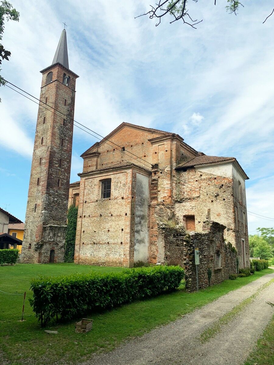
Suno, Pieve di San Genesio: Situated ouside the built-up centre on the ancient Via Francisca and already mentioned in the 11th century, it has been extensively renovated over time. Inside, it preserves an altar, a recently restored fresco and the ancient tomb of the Della Porta family.
Suno, Castle and Parco Della Porta: Situated in the top part of the village and of medieval origin, its current appearance is due to a 19th century renovation; today, part of the building is home to a residence for the elderly. Worthy of note is the park which surrounds the building, rich in century-old plants.
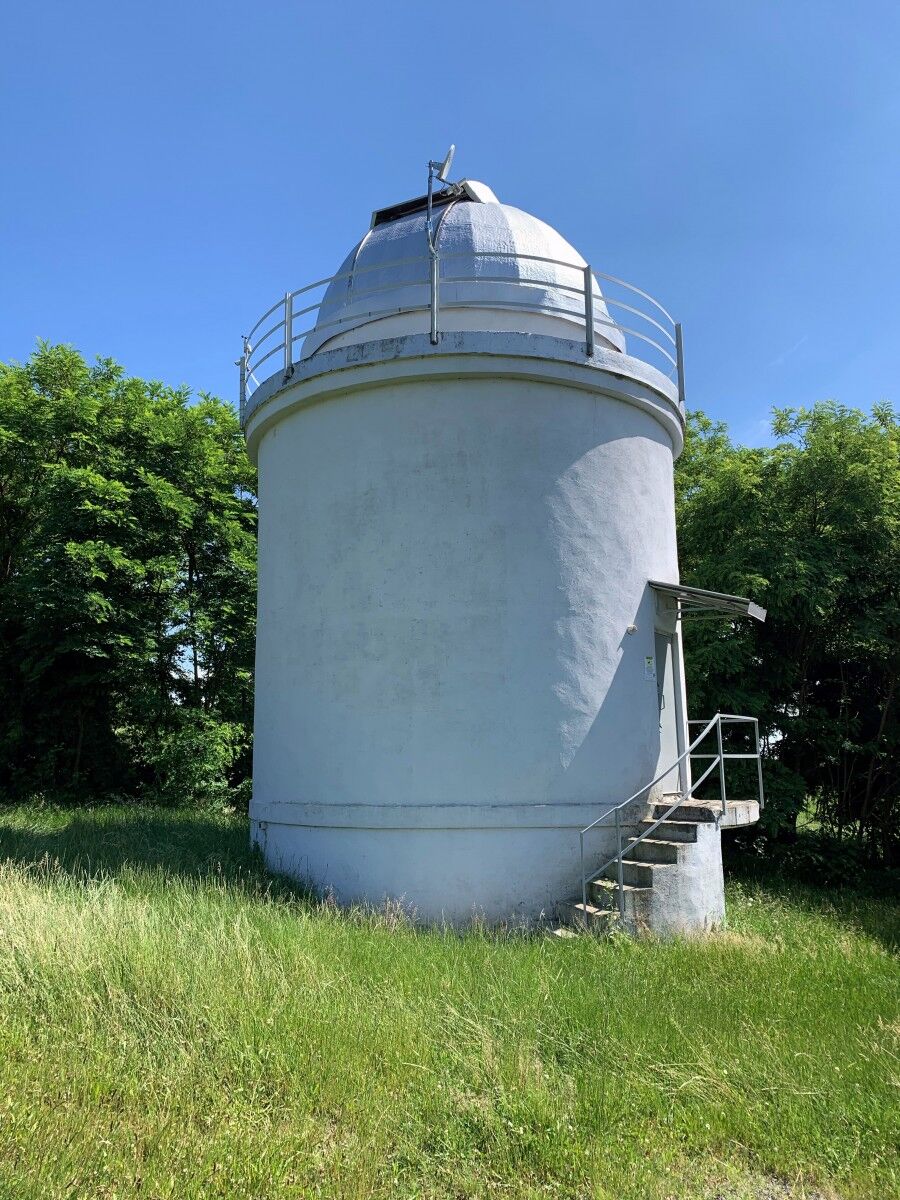
Suno, Astronomical Observatory: In operation since 1968 in Mötziflon, in the vineyards between Mezzomerico and Suno. Research and observations are conducted on the orbital movements of asteroids.
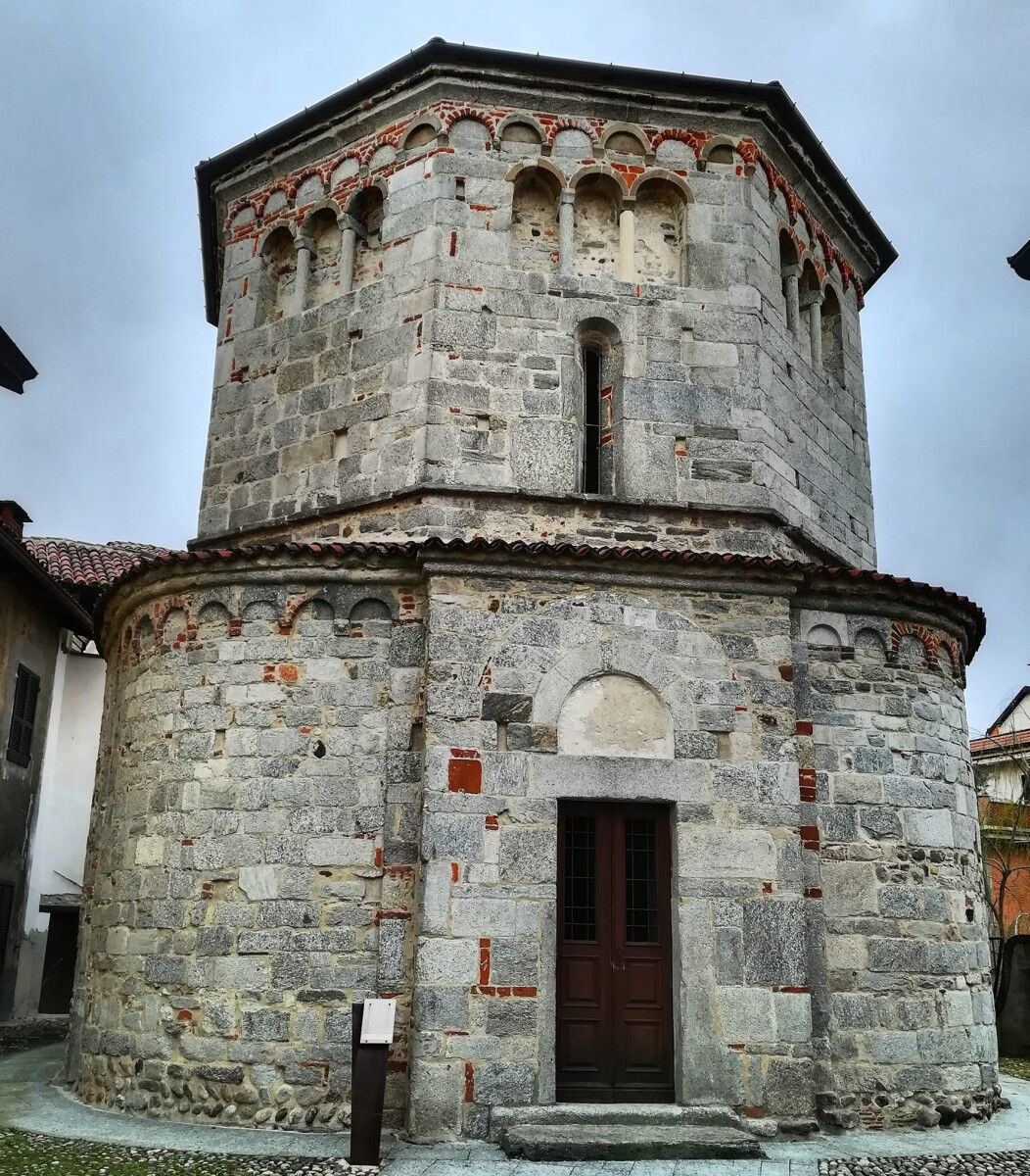
Agrate, Parish Church of San Vittore –Baptistery of San Giovanni: Mentioned for the first time in 976, the parish church was rebuilt in the Romanesque period but renovated many times through the centuries. The 11th-century Baptistery of San Giovanni has a lower irregular plan and an upper octagonal plan. It is adorned with elegant hanging arches and stone columns.
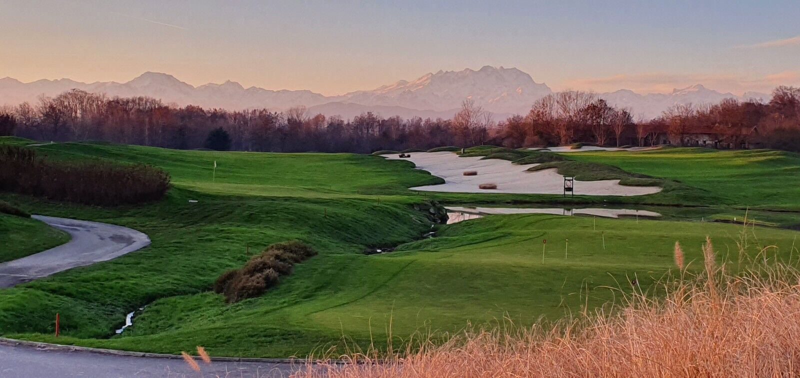
Golf Club Castelconturbia: The circuit, designed by Robert Trent Jones Sr. develops over 3 routes and 27 holes, among century-old trees, streams, lakes and slight undulations. It is one of the most beautiful and famous in Europe, and many international championships have been played here.
Conturbia, Parish Church of San Giorgio: Its construction dates to before 1000, but it has undergone renovation work through the centuries. The pronaos was added in the 17th century.
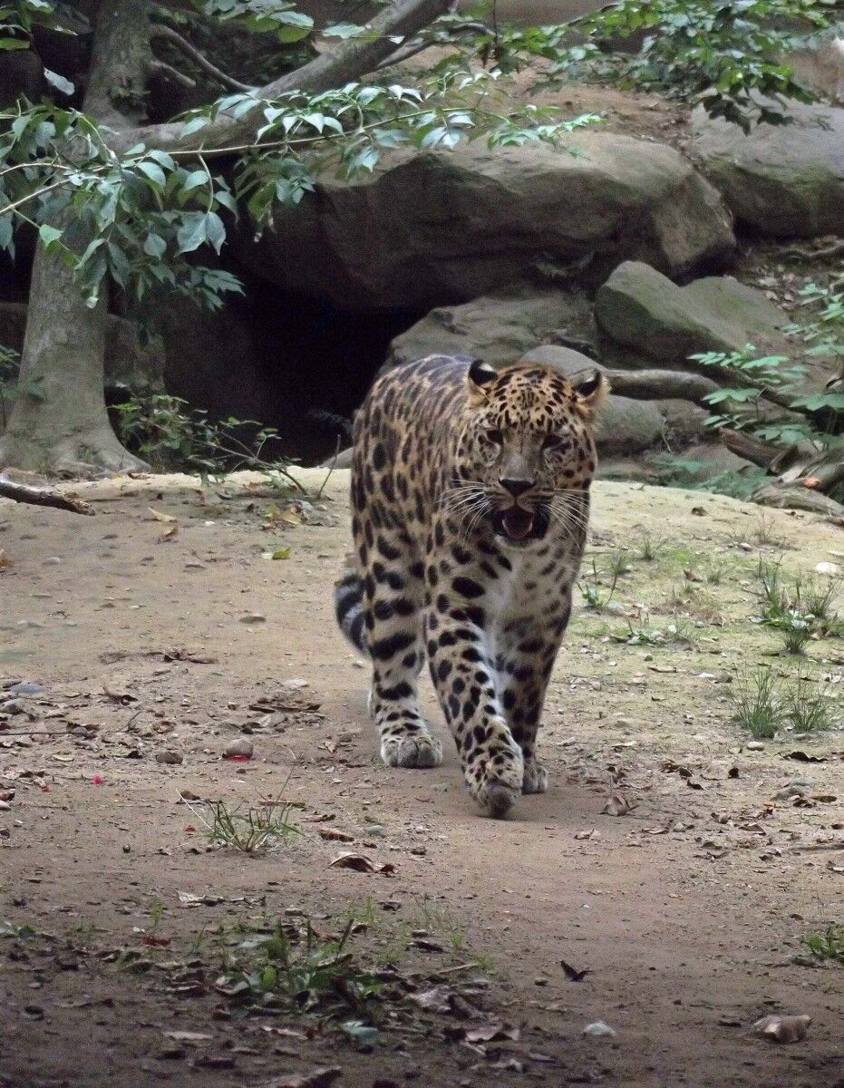
Conturbia, La Torbiera Fauna Park: Set up as a centre for the reproduction and study of endangered animal species. Special attention is given to Italian and European fauna and the world’s rarest feline specimens. The remains of a pile-dwelling, clay artefacts and worked flint, have been found inside the area.
Bogogno, Oratories of Santa Maria in Valle and of San Giacomo: The interior of the first oratory, which rises on the border with the town of Agrate Conturbia, features beautiful pictorial decorations dating to the 15th and 16th centuries. A votive cippus dedicated to Diana was found close to the church in the 19th century. Today, it is preserved in the Lapidarium of Novara. The Oratory of San Giacomo, situated along the road that leads to Veruno, also preserves exquisite 15th century frescoes which depict the Miracles of San Giacomo and Sant’Eligio. They are attributed to the Maestro from Borgomanero and to Giovanni De Campo.
Borgogno, Parish Church of Sant’Agnese: Inside, the church preserves frescoes by native artist Giuseppe Guglielmetti.
Bogogno, Circolo Golf Bogogno: Designed by Robert von Hagge, the route extends along a surface of 200 hectares and is composed of 18 holes. The course, surrounded by an extensive woody area, enjoys a spectacular view of the Alpine chain of Monte Rosa.
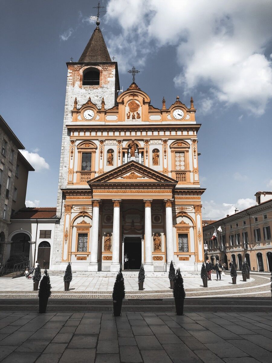
Borgomanero, Collegiate of San Bartolomeo: It rises in the city centre, in its Baroque and Neo-Classical shapes, with the unmistakable facade rich in decorations of terracotta. Inside are preserved magnificent paintings by Morazzone. In front of the church rises the Statue of Mary Immaculate of the 18th century.
Borgomanero, Oratory of San Leonardo: Built in Romanesque style, already mentioned at the end of the 12th century, it presents a single nave and semicircular apse; the construction is formed by large square stones and river pebbles laid out in a herringbone pattern. Of great interest the frescoes attributed to the Maestro from Borgomanero.
Borgomanero, Villa Marazza: Home to the homonymous Foundation and of the Civic Library, it preserves a conspicuous wealth of books, prints, incunabola and parchments. A large park rich in century-old trees is a site for events and shows.
Borgomanero, Church of San Giuseppe: Built towards the late 12th century, it has been renovated many times through the centuries and today it is now in its 17th century forms. It preserves the precious canvas of the Nuvolone del Riposo during the flight to Egypt.
Borgomanero, Vergano Castle: Built in a panoramic position in the homonymous hamlet, the fort dates to the early 14th century, with an elegant 15th century Tower. Interesting the large round arched window topped by the noble coat of arms.
Borgomanero, Ethnographic Museum of the Farming Civilisation “La Manera”: In the Santa Cristina hamlet, housed in the former Palazzo Bono, the museum preserves testimonies of the rural life of the town and territory, with faithful reconstructions of the environments and farmhouses.
Cureggio, Parish Church of Santa Maria Assunta Built in the 12th century the church was enlarged in the 16th century. It preserves beautiful frescoes of the 15th century in its interior.
Cureggio, Baptistery of San Giovanni: Situated in front of the parish church, stands the 12th century Baptistery with octagonal plan and apse; the construction is made from blocks of gneiss, pebbles and brick and roof in black beola stone.
Cureggio, TAM Multimedia Space: Inserted in Casa della Torre, it is a documentation and education centre dedicated to the history of the Novara area, between the Late Antique Period and the Middle Ages, described with reconstructions, models and videos.
Nature Reserve Orientata delle Baragge: Set up in 1992 to protect this area which such particular nature, characterised by a dense moor of ferns and heath, alternated with vast stretches of grassland, which makes this area look like the African Savannah. It offers unique landscapes which change with the seasons. Many species of birds, both sedentary and passing through, such as the white stork, black stork, minor spotted woodpecker, shrike
Fontaneto d’Agogna, Parish church of the Blessed Virgin Mary: Built in the 15th century, it was enlarged in the following centuries, when the Crypt of Sant'Alessandrowas added (1845), designed by Alessandro Antonelli. The church preserves other precious canvases by Tanzio from Varallo and by Sperindio Cagnola.
Golden onion of Cureggio and Fontaneto: Of a golden blonde colour and with a typical horizontal flattening, the onion can reach up to 400 g in weight; it is etremely sweet and can be kept at length even after harvesting. Slow Food presidium since 2013.
Cressa, Oratory of San Giulio: Dating to the 11th century, it was modified during the 15th century. It was once the parish church, but was considered inadequate to the growing needs of the village, and was declassified to oratory.
Cressa, Parish church of Saints Giulio and Amatore: Built in the 17th century, it preserves interesting paintings inside.
Cressa, Sanctuary of Madonna delle Grazie: Close to the railway station, the 17th century church preserves an important fresco of the second half of the 16th century originating from a preceding religious building.
Cressa, Museum of the Silk Worm: Situated in the old cellar of the former Town Hall, it tells the story of the silkworm culture and cultivation of the mulberry from the 17th century to the first half of the 20th century along an exhibition route of panels and videos.
Beliebte Touren in der Nähe
Von der Reisebene bis zu den Hügeln der mittleren Novara-Region
schwerMountainbike45,9 kmMeina to Ranco by SUP
leichtSUP2,76 kmBicinVigna con Antonelli - Itinerario Grigio
mittelMountainbike25,2 kmBicinVigna con Antonelli - Itinerario Rosa
mittelMountainbike40,9 kmBetween the Sesia and the vineyards of the Novara hills
mittelMountainbike40,2 kmAuf den Hügeln von Cavallirio und Boca
leichtWanderung9,73 kmVon Grignasco zum Ara-Felsen
leichtWanderung6,94 kmMeina to Arona
E-Bike31,0 kmMeina - Angera
mittelSUP7,21 kmTra le colline e le aree naturalistiche dell’Alto Novarese
schwerMountainbike39,4 km
Wandern & Tracking


Verpasse keine Angebote und Inspirationen für deinen nächsten Urlaub
Deine E-Mail-Adresse wurde in den Verteiler eingetragen.